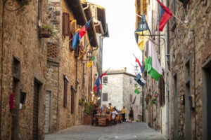
Ring of Lamole
Municipality Greve in Chianti
OUTDOOR / TRAILS / CHIANTI
Departure from the square in Lamole, the center of the village of medieval origin, is characterized by the cultivation of 'Alberello' vines and its landscape marked by the presence of typical dry-stone walls.
These characteristics have led the area to be recognized as a Historic Rural Landscape of International Importance.
The trail winds along nature trails in the typical Chianti woods throughout the upper Greve valley.
The completely naturalistic path through wooded itineraries (chestnut - oak - fir) visits the highest part of the Chianti mountains (899 m) and reaches the locality of San Michele where an ancient settlement of Camaldolese monks arose with permanent and religious buildings
A visit to the Church of San Michele is recommended, which contains an important fresco by the painter Paolo Schiavo dating back to the 14th century (open on request by the management)
Points of interest
- Lamole
- Monte San Michele
Route:
Technical details:
- Starting point: Lamole
- How to get there: Lamole municipal road
- Arrival locality: Lamole
- Access: Lamole
- Difficulty level: E - Hiking
- Any critical points: partly uneven path
- Experience requirements: Medium
- Walking time: 6 hours
- Length: 13 km
- Total ascent: 400m
- Total descent: 400m
- Maximum height: 899m above sea level
- Minimum height: 600m above sea level
- Signposts: CAI trails 28, 28A, 32 and 32
- Best time to tackle the route: Spring, summer, autumn
- Equipment required: hiking clothing and shoes
- Operators offering accessory tourist services to the route:
- Villa San Michele
- Refreshment stop at Lamole
- Farms

Gallery:


")
Related articles
Let yourself be inspired by the legends, stories, and a thousand excellences of this land in the green heart of Tuscany.


-1586x1139")