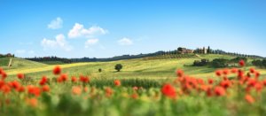
Chianti Vineyards and Woods
Municipality Castelnuovo Berardenga
OUTDOOR / PATHS / CHIANTI
The route can be approached from one of the two main junctions, two of the most important hamlets in the municipal territory: Quercegrossa and Vagliagli.
Vineyards, woods, farms, panoramic viewpoints: 14 km of total immersion in the most characteristic landscape of the Chianti Classico area, joining the largest hamlet in the Berardenga area, Quercegrossa, first mentioned in documents dating back to 1111, once the site of a castle later destroyed by the Florentines, until 1777 a commune and located at the extreme north-western foothills of the territory, to one of the most characteristic villages, Vagliagli, a village first mentioned around the first half of the 12th century due to a donation that was supposed to be functional to the creation of a castle on the rise where the village now stands.
The route runs along trails 330, 330A, 319, 325 and 370.
From fine farms to mills, from beautiful vineyards to fascinating woods, traversed by the soothing sound of streams, until reaching, almost at the highest point of the hike, one of the most beautiful views of the entire Chianti region.
Via trails 323 and 324, it is possible to make variations to the route to reduce its length.
Points of interest
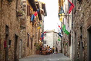
Quercegrossa in the 12th century was the site of a Siena castle destroyed by the Florentines in 1232 and rebuilt, of which there are no traces today. The church dedicated to Saints Jacopo and Niccolò houses a valuable 15th-century 'Pietà'. Vagliagli is a medieval village whose church of S. Cristoforo is attested since 1226 and preserves a 16th-century fresco by the Sienese School. The characteristic mill of Cavasonno and, a few steps from the route, the village of Cignano and the villas of Aiola and Dievole are worth noting.
Route
Technical details:
- Starting locations: Quercegrossa and Vagliagli
- How to get there: By car
- Location of arrival: circular route
- Access: Quercegrossa: located along the regional road 222 which connects Siena and Florence through the Chianti area. Vagliagli can be reached from the north and south along provincial road 102, which connects Siena with Radda in Chianti
- Level of difficulty: E - Hiking
- Any critical points: White roads, forest paths and vineyard roads, no particular difficulties
- Experience requirements: Medium
- Time required: 4 hours
- Length: 14 km
- Total ascent: 535m
- Total descent: 535m
- Maximum height: 575m above sea level
- Minimum height: 270m above sea level
- Signs: CAI signs (red and white stripes) and descriptive panels
- Best time to tackle the route: All year round
- Necessary equipment: walking shoes
- Operators offering accessory tourist services along the route
- Vagliagli:
-Borgo Cignano Equestrian Tourism-
-B&B La Casa di Rompicollo
-Cristina's Garden
-La Pergola del Chianti
-Le Lodoline-San Lorenzo di Fabiane Francesca
-Aiolina
-Dievole
-L'Oliviera
-Podere Fornacino
-The Piaggione
-Villa Serravalle
- Quercegrossa
-Villa Gloria
-Quercegrossa Mill
-Casalgallo

Gallery:
")
")

Related articles
Let yourself be inspired by the legends, stories, and a thousand excellences of this land in the green heart of Tuscany.


-1586x1139")