Berardenga Farms
Municipality Castelnuovo Berardenga
OUTDOOR / PATHS / CHIANTI
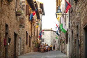
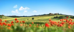
In the immediate vicinity of Castelnuovo Berardenga, here is a route that unites some beautiful farms in the area, rich in history and tradition.
From Pacina, whose origins date back to Etruscan times, with its villa preserved according to strict tradition and seat of the first Italian environmentalist movements, to Felsina, a farm that can also be traced back to Etruscan times, where the presence of a hospital was documented in the 12th century.
Departing preferably from the central square of the village of Castelnuovo, paths 370, 362, 361 and 330 make it possible to circumscribe a precious strip of land, within which rise the forms of two fortresses whose origins date back to the first centuries after the year 1000: Valcortese, mentioned as early as 1030 for the presence of a hospital, and Orgiale, first mentioned at the beginning of the 12th century.
The route can be shortened with two variants, using trails 363 for the first and 363 and 363A for the second, creating two smaller loops of 9.5 and 7.5 km in length respectively. In both cases, the trail crosses woods of indescribable charm, reaching farms rich in history and tradition.
Points of interest
Numerous historical and architectural features can be found along the route, its variants or deviating slightly from the marked routes: the Pacina farmstead, the castles of Orgiale and Valcortese, the Castell'in Villa estate and that of Felsina, until reaching the main town, with the majestic Villa Chigi Saracini, the clock tower and the characteristic old town centre.
Route:
Technical details:
- Starting location: Castelnuovo Berardenga, as well as the various localities along the route
- How to get there: By car
- Arrival locality: circular route
- Access: Castelnuovo Berardenga can be reached from the south via the Siena-Bettolle motorway link road, exiting at Castelnuovo Berardenga and continuing north for about 2.5 km. From the north, via the SP484 dei Castelli del Chianti road. the other towns can be reached by local roads
- Level of difficulty: E - Hiking
- Any critical points: White roads, forest paths and vineyard roads, no particular difficulties
- Experience requirements: Medium
- Walking time: 3.30 hours
- Length: 11.8 km
- Total ascent: 445m
- Total Descent: 445m
- Maximum height: 420m above sea level
- Minimum height: 235m above sea level
- Signs: CAI signs (red and white stripes) and descriptive panels
- Best time to tackle the route: spring to autumn
- Necessary equipment: walking shoes
- Operators offering accessory tourist services along the route:
- Chianti Bicycles
- The Citerna Well
- The Foresteria dell'Aia
- Villa Curina
- Orgiale Castle
- Felsina
- Castell'in Villa
- Allegretti
- Poggio Bonelli
- Fornaci di Sotto
- Pacinina
- Palazzetti
- Podere Calcinaia
- Podere San Quirico

Gallery:
")
")
")
Related articles
Let yourself be inspired by the legends, stories, and a thousand excellences of this land in the green heart of Tuscany.


-1586x1139")