The Etruscans in Berardenga Land
Municipality Castelnuovo Berardenga
OUTDOOR / PATHS / CHIANTI
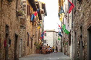
The territory north of the historic centres of San Gusmè and Villa a Sesta is rich in evidence of the Etruscan period.
From the necropolis of Poggione and Bosco alle Pici, sites of finds of great interest, to the settlements that are now the site of buildings modified over time, to the mysteries that shroud the gentle forms of Pian Tondo, a hill that rises just opposite the intersection of paths 366 and 371 and that has yielded significant finds and traces of the probable presence of a noble palace, to the existence of which the finds of chariot parts and princely remains can also be linked, of the Poggione necropolis.
The route, just under 12 km in length, via trails 330. 371, 371A and 366, connects the medieval historic centres of San Gusmè and Villa a Sesta to the above-mentioned places and to the nucleus of Campi, one of the most historically and scenically significant places in the entire Berardenga area, located on a rise on the slopes of the Chianti mountains from which a panorama of impressive beauty can be seen.
It is possible to create two loops, both about 8.5 km long, along trail 366, starting from the historic centres of Villa a Sesta, on the western side, and San Gusmè, on the eastern side. Either in the latter case, or by taking the full trail, it is worth extending the route to 371A to visit the Etruscan necropolis of Poggione.
Points of interest
A route that combines medieval historical emergencies with an area rich in Etruscan finds. From the walled village of San Gusmè to the hill of Campi, near which is the necropolis of Poggione and the hill of Pian Tondo, and then down towards Cetamura, Scandelaia and the other necropolis of Bosco Le Pici, until you reach Villa a Sesta, dominated by the fortress of Sesta, one of the oldest Siena castles of which there is a trace.
Route:
Technical details:
- Starting locations: San Gusmè and Villa Sesta
- How to get there: By car
- Finish locality: circular route
- Access: San Gusmè can be reached from the south along the SP484, with a diversion onto the SP73 about 5 km north of Castelnuovo Berardenga; from the north along the same SP73 coming from Valdarno. Villa a Sesta is located along the SP484, about 6 km from Castelnuovo Berardenga to the south and from Brolio Castle to the north.
- Difficulty level: E - Excursionist
- Any critical points: White roads, woodland paths and vineyard roads, no particular difficulties.
- Experience requirements: Medium
- Walking time: 3.30 hours
- Length: 11.8 km
- Total ascent: 545m
- Total descent: 545m
- Maximum height: 645m above sea level
- Minimum height: 385m above sea level
- Signposts: CAI signs
- Best time to tackle the route: all year round
- Necessary equipment: walking shoes
- Operators offering ancillary tourist services along the route:
- Villa di Sotto
- Casanova
- Borgo Villa a Sesta
- Chiusarella
- Colle ai Lecci
- Le Pici
- Lo Strettoio
- Lo Spugnaccio
- Tattoni Villa Sesta
- Central
- Casaccia
- Borgo San Gusmè
- The House of Elvira
- Boschetto Campacci

Gallery:

")
")
")
Related articles
Let yourself be inspired by the legends, stories, and a thousand excellences of this land in the green heart of Tuscany.


-1586x1139")