Calcinaia Ring route
Municipality of San Casciano in Val di Pesa
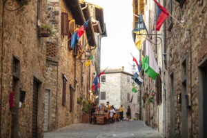
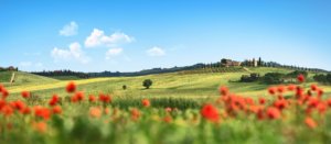
OUTDOOR / TRAILS / CHIANTI
Leave your car at the Calcinaia car park in front of the restaurant and continue along the old road through the village until you reach Via Castelbonsi.
The dirt road winds gently downhill to the former Castle of Castelbonsi at which you turn right towards the church of the same name. A little further on, you reach a panoramic viewpoint over Greve and the plain of Florence.
Just before the church, take a path on the right that descends rapidly to the Battaglio Mill. Having crossed the Borro di Battaglio just before the Mill, take the road that climbs slightly to the right and, after a clearing, enters a thick wood. After a level stretch, the Fonte dei Pollai is reached.
Shortly afterwards, the path curves to the right and then to the left. With a short diversions here, we reach the spot where an air-raid shelter from the Second World War was located. After a slight ascent, we reach the Pian del Melagrano and, in short, the Biscondola. Here the path, which is followed in the direction of Mercatale, briefly skirts the paved road.
When you reach the access road to the Agriturismo Salvadonica, cross the provincial road and follow it. When you reach it, go along, leaving the farmhouse on the left with a wide bend until you reach a clearing below where you turn right. Follow the track that descends into the small valley amidst patches of cut vegetation. Attention must be paid to the bottom of the path as it is pebbly.
We thus reach the private road that runs alongside the Terzona near two distinctive yellow posts topped by the characteristic orange bell for visual aerial recognition of the methane pipeline. Turn right and follow the road until you find an evident path with a sign to go up the slope.
Follow the track and go through a gate, continuing on until you find an evident path on the right that leads uphill to a group of houses, from which you continue along an unpaved road (Via Canali) until you reach the provincial road and turn left to arrive in Calcinaia at the starting point.
Points of interest
- Church of Castelbonsi
- Fonte dei Pollai spring
- Mercatale Val di Pesa
- Villa Le Corti
Route:
Technical details:
- Starting point: Calcinaia
- How to get there: By car. From San Casciano head towards Mercatale
- Arrival locality: Calcinaia
- Access: Calcinaia (road SP12 between San Casciano and Mercatale)
- Level of difficulty: E - Excursionist
- Possible criticality: Short stony sections
- Experience requirements: Medium
- Time required: 4 hours
- Length: 10.4 km
- Total ascent: 219m
- Total descent: 219m
- Maximum height: 307m above sea level
- Minimum height: 153m above sea level
- Signposts: Red/white signs, arrows indicating direction of travel and walking time
- Best time of year to tackle the route: All year round
- Necessary equipment: walking shoes
- Operators offering additional tourist services along the route: ND

Gallery:


Related articles
Let yourself be inspired by the legends, stories, and a thousand excellences of this land in the green heart of Tuscany


-1586x1139")