Terzona ring
Municipality San Casciano in Val di Pesa
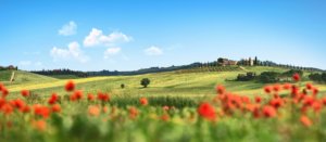
OUTDOOR / TRAILS / CHIANTI
The starting point is at Calzaiolo along the Cassia road, past the bridge over the Terzona stream, where you park your car.
Take the gravel road that climbs in the direction of the FI-Siena motorway. At the first fork, turn left downhill passing under the high bridge of the motorway. Follow the unpaved road keeping the Terzona stream on your left until you reach a ford, which you cross. Follow the dirt road with the stream on the right and vineyards on the left.
After about 2 km, you reach a distinctive bend in the stream with a steep conglomerate bank and cross a path from the right. This will be the point where we will join up on the return journey.
We continue along the dirt road, leaving other small roads on the left, and after about 4.3 km from the start, we reach the paved road between Mercatale and Montefiridolfi.
We turn right and cross the bridge over the Terzona. After about 300 metres, we turn left to via Vallacchio and, on a clear uphill stretch, we cross several groups of houses. The road now climbs more gently and the view widens out with great panoramas to the north, with the eye reaching as far as the Apennines and, in good visibility conditions, as far as the Apuan Alps.
We continue along the dirt road via Vallacchio until we reach the asphalt road with the imposing Palagio castle on the left. A small tabernacle marks this junction.
Turn right along the road until passing the solitary Pieve di Santo Stefano a Campoli. Follow the road downhill again for a short distance until you come to Via della Villa Barberino on the right. Take this unpaved road and follow it, leaving a fork in the road to the left and then the large villa with its adjoining cellar.
The farm road further on turns left towards an impluvium, crosses a small wood and then turns left, descending on a barely visible track leaving some ruins of the Vernace farmhouse on the right.
We descend on a barely visible track until we skirt a small stream half-hidden by vegetation. Turn right and leave the open fields to cross a point where the trail crosses a stretch of about 100 metres through dense vegetation. You leave the section with vegetation and reach a farm road where to turn left.
At the nearby fork, keep to the left without climbing until you cross the old road coming from the ruin above on the left. Here, turn right and cross the Terzona stream over a characteristic old bridge. Follow the natural-bed farm road uphill and soon reach the tarmac road where you turn left.
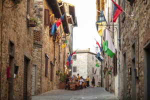
We reach the main road and enter the village of Montefiridolfi. We cross the characteristic village along the via di Santa Maria a Macerata. At the fork outside the village, we turn left to via Petigliolo, which immediately becomes a dirt road. The road is very scenic as it is on a ridge.
We follow the road for a long time, alternating between forest and cultivation, until it is no longer practicable with cars. We follow the track again, which becomes a path that enters a beautiful oak forest. The path on a round cobblestone surface descends until it reaches the bottom of the small valley.
On the left, a fork with a path leads up the valley floor. You still follow the path to the right and reach a ford, which you cross carefully. After a short distance, the road left on the way up is crossed.
Turn left and follow the path back to the start.
Points of interest
- Old Calzaiolo hospital
- Il Palagio castle
- Parish church of S.Stefano a Campoli
- Montefiridolfi
Route:
Technical details:
- Starting point: Calzaiolo
- How to get there: By car. From San Casciano follow the signs for Bargino
- Arrival locality: Calzaiolo
- Access: from San Casciano follow the SS2 Cassia road towards Bargino
- Level of difficulty: E - Excursionist
- Any critical points: no
- Experience requirements: Medium
- Time required: 6 hours
- Length: 13.4 km
- Total ascent: 196m
- Total descent: 196m
- Maximum height: 326m above sea level
- Minimum height: 131m above sea level
- Signposts: Red/white signs, arrows indicating direction of travel and walking time
- Best time of year to tackle the route: All year round
- Necessary equipment: walking shoes
- Operators offering additional tourist services along the route: ND

Gallery:


Related articles
Let yourself be inspired by the legends, stories, and a thousand excellences of this land in the green heart of Tuscany


-1586x1139")